
MarineTraffic – Suivi des navires en direct dans le monde entier
Explorez en temps réel les positions des navires, les informations sur les navires, les ports et le trafic maritime mondial basé sur le système AIS grâce à MarineTraffic.
Carte des navires en direct de MarineTraffic
Utilisez la carte interactive pour explorer les positions des navires et le trafic maritime signalés dans le monde entier. Les positions disponibles dépendent de la couverture AIS et des données fournies par MarineTraffic.
Qu'est-ce que MarineTraffic ?
MarineTraffic est un service de suivi maritime en ligne qui affiche les positions des navires, les informations sur les navires et les données portuaires, principalement à partir des données AIS et d'autres sources de données maritimes.
Les utilisateurs peuvent explorer les navires commerciaux, les navires à passagers, les pétroliers, les ferries, les bateaux de plaisance et bien d'autres types d'embarcations. Selon les données disponibles, les profils des navires peuvent inclure leur identification, leur destination, leur vitesse, leur cap, leurs dimensions et des informations relatives au voyage.
MarineTraffic propose des services gratuits et payants. Les informations de base sur les cartes et les navires sont accessibles sans abonnement, tandis que le suivi avancé, les données satellitaires et les outils maritimes professionnels nécessitent un abonnement payant.
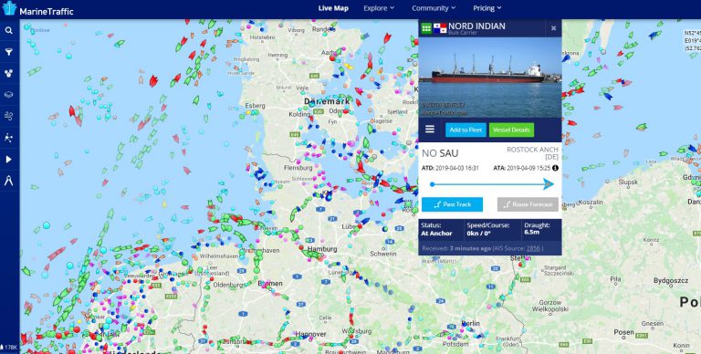
Explorez les navires et les ports du monde entier
MarineTraffic combine les données de position des navires avec des outils cartographiques interactifs. Les utilisateurs peuvent rechercher des navires spécifiques, consulter les informations disponibles et explorer le trafic autour des ports et des zones côtières.
Le suivi public des navires est particulièrement utile pour suivre les paquebots de croisière, les cargos, les pétroliers et autres navires commerciaux. La disponibilité des positions et les intervalles de mise à jour peuvent varier en fonction de la couverture réseau et de la source des données.
Comment fonctionne MarineTraffic?
MarineTraffic utilise des données maritimes, notamment l'AIS, pour afficher les positions des navires et les informations les concernant sur des cartes interactives.
Identité du vaisseau
L'AIS peut transmettre des identifiants tels que le MMSI, l'indicatif d'appel et d'autres informations relatives au navire.
Position
Les coordonnées de latitude et de longitude relevées peuvent être affichées sur la carte en direct lorsque la couverture AIS est adéquate.
Vitesse et parcours
Les messages AIS peuvent inclure la vitesse fond et le cap fond pour les navires en mouvement.
Données de voyage
Selon le navire, la destination, l'heure d'arrivée prévue et d'autres détails relatifs au voyage peuvent également être transmis.
Suivi au-delà des normes AIS
MarineTraffic peut également afficher certains rapports de position provenant de navires qui n'utilisent pas de transpondeur AIS conventionnel, en fonction du service et de la méthode de rapport utilisés.
Les informations de position peuvent être transmises par le biais d'appareils mobiles connectés, d'équipements de suivi compatibles ou d'autres méthodes de transmission prises en charge. Ces transmissions doivent être interprétées séparément des transmissions AIS standard.
Symboles et types de navires de MarineTraffic
Différentes couleurs et symboles permettent de distinguer les catégories de navires sur la carte. Le tableau ci-dessous reprend le guide visuel existant de Ship-Tracker.org pour les navires en mouvement et à l'arrêt.
| Type de navire | En route | Arrêté |
|---|---|---|
| Navire marchand |  |  |
| Pétrolier |  |  |
| Navire à passagers |  |  |
| Vedette |  |  |
| Remorqueur |  |  |
| Bateau de pêche |  |  |
| Bateau de loisir |  |  |
| Autre navire |  |  |
| Aide à la navigation |  | |
Surveillance des pétroliers et du transport maritime mondial
MarineTraffic permet d'explorer les mouvements des pétroliers, la marine marchande et le trafic maritime commercial en général. Ce service s'avère donc utile non seulement aux passionnés, mais aussi à toute personne intéressée par les routes maritimes, la logistique et le commerce international.
Explication du trafic maritime
La vidéo suivante offre une introduction supplémentaire au suivi des navires et à la surveillance maritime liée à MarineTraffic.
[su_youtube url=”https://www.youtube.com/watch?v=XBvvgm1OhKk”]
Pourquoi MarineTraffic utilise l'AIS
L'AIS est l'une des sources de données les plus importantes utilisées pour le suivi public des navires, car elle permet aux navires de transmettre des informations d'identification et de navigation.
Le système AIS peut transmettre des informations telles que l'identité, la position, la vitesse et le cap d'un navire. Les stations de réception côtières captent ces signaux près des côtes et des ports, tandis que le système AIS par satellite étend la couverture à des zones océaniques plus reculées.
L'AIS a été développé principalement comme aide à la navigation maritime et à la connaissance de la situation. Les services de suivi publics utilisent les données AIS reçues pour visualiser les mouvements des navires, mais ces informations ne doivent pas être considérées comme un substitut aux systèmes de navigation professionnels.
Classe A et classe B de l'AIS
Classe A de l'AIS
Les transpondeurs de classe A sont utilisés par de nombreux navires commerciaux et navires à passagers de grande taille, sous réserve des exigences de transport applicables.
Classe B de l'AIS
Les dispositifs de classe B sont couramment utilisés par les petits navires et les bateaux de plaisance qui ne sont pas soumis aux mêmes exigences que les grands navires commerciaux.
AIS côtier
Les stations de réception côtières et portuaires captent les transmissions des navires dans leur zone de réception.
AIS par satellite
Les satellites équipés de récepteurs AIS peuvent étendre la couverture de suivi des navires à des zones éloignées des côtes.
Quelles informations pouvez-vous trouver ?
En fonction du navire et des données MarineTraffic disponibles, les utilisateurs pourront explorer diverses informations sur les navires et les voyages.
Vous recherchez un navire en particulier ?
Recherchez par nom de navire, numéro IMO, MMSI ou indicatif d'appel et ouvrez un profil de navire disponible sur Ship-Tracker.org.
Applications mobiles MarineTraffic
MarineTraffic propose des applications mobiles permettant aux utilisateurs de consulter les positions des navires et les informations les concernant sur smartphones et tablettes.
iPhone et iPad
MarineTraffic est disponible pour les appareils mobiles Apple via l'App Store.
Android
Les utilisateurs Android peuvent accéder à MarineTraffic via le Google Play Store.
Recherche de navires
Les utilisateurs mobiles peuvent rechercher des navires et consulter les détails des navires disponibles ainsi que leurs positions signalées.
Suivi cartographique
Les cartes interactives permettent aux utilisateurs d'explorer le trafic maritime local et mondial, même en déplacement.
Qui utilise MarineTraffic ?
MarineTraffic est utilisé par un large public comprenant des professionnels du secteur maritime, des passionnés de transport maritime, des adeptes des croisières, des observateurs portuaires et des personnes intéressées par le commerce mondial et les mouvements de navires.
Les utilisateurs professionnels peuvent utiliser les outils de suivi maritime dans le cadre de la logistique, de la planification opérationnelle ou de l'analyse de marché, tandis que les utilisateurs privés suivent souvent des navires spécifiques, explorent des ports ou observent simplement le trafic maritime dans le monde entier.
Peut-on utiliser MarineTraffic gratuitement ?
MarineTraffic offre un accès aux fonctions de base de suivi des navires et de cartographie, tandis que les fonctionnalités plus avancées peuvent nécessiter une inscription ou un abonnement payant. La disponibilité exacte des fonctionnalités gratuites et payantes est susceptible d'évoluer.
Pour les utilisateurs occasionnels, la carte publique est un outil pratique pour explorer le trafic maritime en temps réel et rechercher des navires. Les utilisateurs professionnels peuvent opter pour des services complémentaires lorsqu'ils ont besoin d'un accès à des données plus complètes, d'une couverture satellite ou d'outils d'analyse plus avancés.
FAQ sur le trafic maritime
Qu'est-ce que MarineTraffic ?
MarineTraffic est un service de suivi maritime en ligne qui affiche les positions des navires, les informations sur les navires et les données portuaires à partir des sources de données maritimes disponibles telles que l'AIS.
MarineTraffic affiche-t-il les positions des navires en temps réel ?
MarineTraffic peut afficher les positions récentes des navires, mais les intervalles de mise à jour et la couverture dépendent de la réception AIS, des données satellitaires et du service utilisé.
Que signifient les différentes couleurs des navires ?
Différents symboles et couleurs cartographiques permettent de distinguer les types et le statut des navires. Le guide des symboles présenté sur cette page fournit des exemples pour plusieurs catégories de navires courantes.
Puis-je suivre les pétroliers avec MarineTraffic ?
Oui. Les pétroliers et de nombreux autres types de navires commerciaux peuvent être affichés lorsque leur position est disponible via le service de suivi.
MarineTraffic utilise-t-il le système AIS par satellite ?
Le système AIS par satellite peut être utilisé pour étendre la couverture de suivi des navires au-delà de la portée des stations de réception terrestres.
MarineTraffic est-il gratuit ?
Les fonctions de base de suivi public peuvent être disponibles gratuitement, tandis que les services avancés et les fonctionnalités professionnelles peuvent nécessiter un abonnement payant.


