
MarineTraffic – Live Ship Tracking Worldwide
Explore live vessel positions, ship information, ports and AIS-based maritime traffic around the world with MarineTraffic.
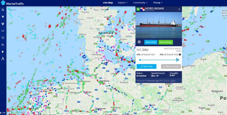
MarineTraffic Live Ship Map
Use the interactive map to explore reported vessel positions and maritime traffic around the world. Available positions depend on AIS coverage and the data shown by MarineTraffic.
What Is MarineTraffic?
MarineTraffic is an online maritime tracking service that displays vessel positions, ship information and port-related data based primarily on AIS and other maritime data sources.
Users can explore commercial ships, passenger vessels, tankers, ferries, pleasure craft and many other vessel types. Depending on the available data, ship profiles may include vessel identification, destination, speed, course, dimensions and voyage-related information.
MarineTraffic offers both free and paid services. Basic map and vessel information can be available without a subscription, while advanced tracking, satellite data and professional maritime tools may require a paid plan.
Explore Ships and Ports Worldwide
MarineTraffic combines vessel position reports with interactive map tools. Users can search for specific ships, inspect available vessel details and explore traffic around ports and coastal regions.
Public ship tracking is particularly useful for following cruise ships, cargo vessels, tankers and other commercial traffic. Position availability and update intervals can vary depending on receiving coverage and the underlying data source.
Kuinka MarineTraffic toimii?
MarineTraffic uses maritime data, especially AIS, to display reported vessel positions and ship information on interactive maps.
Vessel Identity
AIS can transmit identifiers such as MMSI, call sign and other vessel-related information.
Position
Reported latitude and longitude can be displayed on the live map when suitable AIS coverage is available.
Speed & Course
AIS messages can include Speed Over Ground and Course Over Ground for moving vessels.
Voyage Data
Depending on the ship, destination, ETA and other voyage-related details may also be transmitted.
Tracking Beyond Standard AIS
MarineTraffic can also display selected position reports from vessels that do not rely on a conventional AIS transponder, depending on the service and reporting method used.
Position information may be contributed through connected mobile devices, compatible tracking equipment or other supported reporting methods. Such reports should be understood separately from standard AIS transmissions.
MarineTraffic Ship Symbols and Vessel Types
Different colors and symbols help distinguish vessel categories on the map. The table below preserves the existing Ship-Tracker.org visual guide for moving and stopped vessels.
| Ship Type | On the Way | Stopped |
|---|---|---|
| Kauppalaiva |  |  |
| Tankkeri |  |  |
| Matkustaja-alus |  |  |
| Pikavene |  |  |
| Hinaaja |  |  |
| Kalastusvene |  |  |
| Vapaa-ajan vene |  |  |
| Other ship |  |  |
| Navigointiapu |  | |
Monitoring Tankers and Global Shipping
MarineTraffic can be used to explore tanker movements, merchant shipping and other commercial maritime traffic. This makes the service useful not only for enthusiasts but also for people interested in shipping routes, logistics and global trade.
MarineTraffic Explained
The following video provides an additional introduction to ship tracking and MarineTraffic-related maritime monitoring.
[su_youtube url=”https://www.youtube.com/watch?v=XBvvgm1OhKk”]
Why MarineTraffic Uses AIS
AIS is one of the most important data sources used for public vessel tracking because it allows ships to transmit identification and navigation-related information.
AIS can transmit information such as vessel identity, position, speed and course. Shore-based receiving stations can collect these signals near coastlines and ports, while satellite-based AIS can extend coverage into more remote ocean areas.
AIS was developed primarily as an aid to maritime navigation and situational awareness. Public tracking services use received AIS data to visualise vessel movements, but the information should not be treated as a replacement for professional navigation systems.
AIS Class A and Class B
AIS Class A
Class A transponders are used by many larger commercial vessels and passenger ships subject to applicable carriage requirements.
AIS Class B
Class B devices are commonly used by smaller vessels and pleasure craft that are not subject to the same requirements as larger commercial ships.
Shore AIS
Coastal and port receiving stations collect vessel transmissions within their reception range.
Satellite AIS
Satellites equipped with AIS receivers can extend vessel tracking coverage into areas far from shore.
What Information Can You Find?
Depending on the vessel and available MarineTraffic data, users may be able to explore a range of ship and voyage information.
Looking for a Specific Vessel?
Search by vessel name, IMO number, MMSI or call sign and open an available Ship-Tracker.org vessel profile.
MarineTraffic Mobile Apps
MarineTraffic offers mobile applications that allow users to explore vessel positions and ship information on smartphones and tablets.
iPhone & iPad
MarineTraffic is available for Apple mobile devices through the App Store.
Android
Android users can access MarineTraffic through the Google Play Store.
Vessel Search
Mobile users can search for ships and inspect available vessel details and reported positions.
Map Tracking
Interactive maps allow users to explore nearby and worldwide maritime traffic while on the move.
Who Uses MarineTraffic?
MarineTraffic is used by a broad audience that includes maritime professionals, shipping enthusiasts, cruise followers, port observers and people interested in global trade and vessel movements.
Professional users may use maritime tracking tools as part of logistics, operational planning or market analysis, while private users often follow specific ships, explore ports or simply observe maritime traffic around the world.
Can You Use MarineTraffic for Free?
MarineTraffic provides access to basic public vessel tracking and map functions, while more advanced features may require registration or a paid subscription. The exact availability of free and premium features can change over time.
For casual users, the public map can be a useful way to explore current maritime traffic and search for vessels. Professional users may choose additional services when they need broader data access, satellite coverage or more advanced analytical tools.
MarineTraffic FAQ
What is MarineTraffic?
MarineTraffic is an online maritime tracking service that displays vessel positions, ship information and port-related data based on available maritime data sources such as AIS.
Does MarineTraffic show live ship positions?
MarineTraffic can display recent vessel positions, but update intervals and coverage depend on AIS reception, satellite data and the service being used.
What do the different ship colors mean?
Different map symbols and colors are used to distinguish vessel types and status. The symbol guide on this page provides examples for several common vessel categories.
Can I track tankers with MarineTraffic?
Yes. Tankers and many other commercial vessel types can be displayed when their positions are available through the tracking service.
Does MarineTraffic use satellite AIS?
Satellite AIS can be used to extend vessel tracking coverage beyond the range of shore-based receiving stations.
Is MarineTraffic free?
Basic public tracking functions may be available for free, while advanced services and professional features can require a paid plan.


