
Cruiseschipvolgsysteem – Live scheepsposities
Volg cruiseschepen wereldwijd, bekijk de actuele posities van schepen en ontdek hoe AIS live tracking van cruiseschepen mogelijk maakt.
Live plattegrond van het cruiseschip
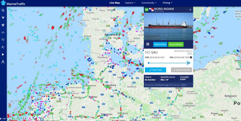
Gebruik de interactieve zeekaart om cruiseschepen en andere vaartuigen over de hele wereld te verkennen. Beschikbare posities zijn gebaseerd op AIS-gegevens die door de trackingprovider worden ontvangen.
Volg cruiseschepen over de hele wereld
Het volgen van cruiseschepen is handig voor passagiers, familieleden, cruiseliefhebbers en iedereen die geïnteresseerd is in scheepvaartverkeer. Een live scheepskaart laat zien waar een cruiseschip zich momenteel bevindt, in welke richting het vaart en welke bestemming via AIS is doorgegeven.
Moderne trackingdiensten combineren identificatiegegevens van schepen met gerapporteerde posities op een interactieve kaart. Afhankelijk van de dekking en de door het schip verzonden informatie, kunnen gebruikers ook de snelheid, koers, bestemming, geschatte aankomsttijd en andere scheepsgegevens bekijken.
Hoe vind je een cruiseschip?
Om een specifiek cruiseschip te vinden, gebruikt u de zoekfunctie van de live kaart en voert u de naam van het schip in. Als het schip in het volgsysteem beschikbaar is, kan de gerapporteerde positie op de kaart worden weergegeven, samen met beschikbare reis- en identificatiegegevens.
Cruiseschepen vormen slechts een onderdeel van het wereldwijde scheepvaartverkeer. Op dezelfde AIS-gebaseerde kaarten kunnen ook veerboten, vrachtschepen, tankers, containerschepen, sleepboten en vele andere scheepstypen worden weergegeven.
Cruiseschiplocaties over de hele wereld
Cruiseschepen varen over grote oceanen, langs kustgebieden en naar populaire toeristische bestemmingen. AIS maakt het mogelijk om veel van deze bewegingen te volgen via maritieme datanetwerken, zowel vanaf de wal als via satellieten.
Huidige functie
Bekijk de laatst gerapporteerde positie wanneer AIS-dekking en scheepscommunicatie beschikbaar zijn.
Snelheid
De snelheid over de grond kan aangeven hoe snel het vaartuig zich voortbeweegt op het moment van een AIS-rapport.
Cursus
De functie 'Koers over de grond' geeft informatie over de gerapporteerde vaarrichting van het schip.
Bestemming en verwachte aankomsttijd (ETA)
Sommige schepen zenden een bestemming en een geschatte aankomsttijd uit als onderdeel van hun reisgerelateerde AIS-informatie.
Hoe wordt de functie op een cruiseschip bepaald?
AIS staat voor Automatic Identification System (automatisch identificatiesysteem). Het is een maritiem radiosysteem dat door schepen wordt gebruikt om identificatie-, positie- en navigatie-informatie te verzenden. AIS werd voornamelijk ontwikkeld om het situationeel bewustzijn te verbeteren en schepen te helpen andere schepen in de buurt te identificeren.
Afhankelijk van de status en beweging van het schip kunnen AIS-berichten met verschillende tussenpozen worden verzonden. Ontvangststations en andere maritieme datanetwerken verzamelen deze signalen en kunnen de gerapporteerde posities beschikbaar maken op online scheepsvolgkaarten.
De AIS-dekking is niet overal gelijk. Een schip kan tijdelijk van een openbare kaart verdwijnen wanneer het buiten het ontvangstbereik is, wanneer er geen satellietgegevens beschikbaar zijn of wanneer er geen recente positie is ontvangen.
Gratis tracking van cruiseschepen
Online scheepsvolgsystemen maken het mogelijk om veel scheepsbewegingen te volgen zonder gespecialiseerde maritieme apparatuur. Diensten zoals MarineTraffic en VesselFinder bieden interactieve kaarten waarop beschikbare AIS-posities en scheepsinformatie worden weergegeven.
Op zoek naar een cruiseschip?
Zoek op Ship-Tracker.org op scheepsnaam, IMO-nummer, MMSI of roepsein.
Waarom het volgen van cruiseschepen belangrijk is
AIS is een belangrijk onderdeel van de moderne scheepvaart, omdat het schepen helpt om ander scheepvaartverkeer in de buurt te identificeren en het situationeel bewustzijn te verbeteren. Voor het publiek maakt dezelfde technologie het ook mogelijk om veel cruiseschepen en andere commerciële vaartuigen te volgen via online kaarten.
Openbare scheepsvolgsystemen moeten niet worden verward met de professionele navigatiesystemen die aan boord van een schip worden gebruikt. Online posities kunnen vertraagd of onvolledig zijn, dus openbare kaarten moeten worden beschouwd als informatieve hulpmiddelen voor het volgen van schepen en niet als cruciale navigatiesystemen voor de veiligheid.
MarineTraffic en VesselFinder
Zowel MarineTraffic als VesselFinder bieden zeekaarten aan op basis van beschikbare AIS-informatie. Deze kunnen worden gebruikt om cruiseschepen, passagiersschepen en ander scheepvaartverkeer over de hele wereld te verkennen.
Ship-Tracker.org biedt ook individuele scheepspagina's met scheepsidentificaties, scheepsgegevens en beschikbare tools voor realtime tracking.
Veelgestelde vragen over het volgen van cruiseschepen
Hoe kan ik een cruiseschip volgen?
Gebruik de live scheepskaart of de scheepszoekfunctie om het cruiseschip op naam te zoeken. Als er een recente AIS-positie beschikbaar is, kan het schip op de kaart worden weergegeven.
Kan ik de huidige positie van een cruiseschip zien?
Ja, wanneer er een recente AIS-positie beschikbaar is via de trackingprovider. De dekking en update-intervallen kunnen variëren afhankelijk van de locatie van het schip.
Wat betekent AIS?
AIS staat voor Automatic Identification System (automatisch identificatiesysteem). Schepen gebruiken het om identificatie-, positie- en navigatiegegevens te verzenden.
Worden de posities van cruiseschepen in realtime weergegeven?
Posities kunnen vrijwel realtime worden weergegeven, maar vertragingen zijn mogelijk. De updatefrequentie is afhankelijk van de AIS-ontvangst, de transmissies van het schip en de trackingprovider.
Kan ik een cruiseschip zoeken op basis van IMO of MMSI?
Ja. Ship-Tracker.org ondersteunt scheepsidentificatie op basis van scheepsnaam, IMO-code, MMSI-code en roepnaam, mits de relevante gegevens en een openbare scheepspagina beschikbaar zijn.
Waarom verdwijnen cruiseschepen soms van de kaart?
Een schip kan tijdelijk geen zichtbare positie hebben als gevolg van beperkte AIS-ontvangst, satellietdekking, transmissiestoringen of vertragingen in de dataverbinding.


