
VesselFinder: Seguimiento de buques en tiempo real a nivel mundial.
Localiza buques en todo el mundo, explora las posiciones AIS en tiempo real y descubre cómo VesselFinder muestra información sobre barcos, puertos, rutas y buques.
Seguimiento de buques en tiempo real con VesselFinder
Utilice el mapa interactivo de VesselFinder para explorar la posición de los buques en todo el mundo. Las ubicaciones disponibles dependen de la cobertura AIS, las transmisiones de los buques y los datos que muestra VesselFinder.
¿Qué es VesselFinder?
VesselFinder es un servicio de seguimiento marítimo en línea que utiliza el AIS y otras fuentes de datos marítimos para mostrar la posición de los buques y la información sobre las embarcaciones en mapas interactivos.
Los usuarios pueden explorar buques comerciales, de pasajeros, petroleros, militares, pesqueros, veleros y demás tráfico marítimo. Según los datos disponibles, las páginas de los buques pueden incluir identificadores, destino, velocidad, ruta, detalles del viaje e información histórica.
VesselFinder también proporciona herramientas relacionadas con puertos, movimientos de buques, datos marítimos e información histórica del AIS.
¿Cómo funciona VesselFinder?
VesselFinder procesa los datos AIS de las redes receptoras y muestra las posiciones reportadas de los buques en un mapa marítimo interactivo.
Identidad del buque
Los datos AIS disponibles pueden incluir el nombre del buque, el número MMSI, el número IMO y el distintivo de llamada.
Posición en vivo
La latitud y la longitud indicadas pueden visualizarse cuando se dispone de datos AIS recientes.
Velocidad y recorrido
La velocidad y el rumbo sobre el terreno pueden ayudar a mostrar cómo se mueve una embarcación.
Información del viaje
Dependiendo del buque, el destino, la hora estimada de llegada y otros datos relacionados con el viaje también pueden ser visibles.
Explicación de VesselFinder
El siguiente vídeo ofrece una introducción adicional a VesselFinder y al seguimiento de buques en tiempo real.
[su_youtube url=”https://www.youtube.com/watch?v=fIbwRnq4jdo”]
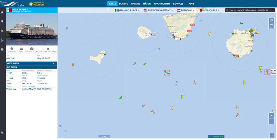
Explora más allá de una posición en un barco.
VesselFinder ofrece más que una simple ubicación. Según el tipo de embarcación y los datos disponibles, los usuarios también pueden encontrar fotos, información sobre el destino, la velocidad, el tipo de buque y otros detalles de identificación o del viaje.
La información histórica y los datos de movimiento pueden ayudar a los usuarios a comprender por dónde ha viajado un buque y cómo ha evolucionado su viaje a lo largo del tiempo.
Símbolos y tipos de buques de VesselFinder
VesselFinder utiliza distintos símbolos para representar las categorías de buques y su estado. La tabla que aparece a continuación conserva la guía de símbolos existente de Ship-Tracker.org.
| Tipo de barco | Símbolo | Símbolo alternativo |
|---|---|---|
| Barco mercante |  |  |
| Petrolero |  |  |
| Barcos militares |  |  |
| Buque de pasajeros |  |  |
| Barco de pesca |  |  |
| Lancha rápida |  |  |
| Velero |  |  |
| Otro barco |  |  |
| Otros objetos |  |  |
Características principales de VesselFinder
VesselFinder combina el seguimiento en tiempo real de buques con herramientas de búsqueda, información sobre barcos y datos marítimos.
Buscador de embarcaciones y AIS
VesselFinder depende en gran medida del AIS, el Sistema de Identificación Automática utilizado por muchos buques para transmitir información de identificación y navegación.
Las señales AIS pueden incluir la identificación del buque, su posición, velocidad, rumbo y otros datos de la travesía. Las redes receptoras terrestres y satelitales pueden recopilar estas transmisiones y poner parte de la información a disposición del público a través de servicios de seguimiento de buques.
El AIS es una ayuda importante para el conocimiento de la situación marítima, pero el seguimiento público de buques no debe considerarse un sustituto de los sistemas profesionales de navegación o de prevención de colisiones.
¿Busca una embarcación específica?
Busque por nombre del buque, número IMO, MMSI o distintivo de llamada y abra un perfil de buque disponible en Ship-Tracker.org.
Aplicaciones móviles de VesselFinder
VesselFinder también se puede utilizar en dispositivos móviles, lo que permite explorar los movimientos de los buques y la información sobre los mismos mientras se viaja.
Androide
VesselFinder ofrece una aplicación para Android que permite el seguimiento de embarcaciones desde dispositivos móviles.
iOS
VesselFinder también está disponible para dispositivos móviles de Apple.
Mapa en vivo
Los usuarios de dispositivos móviles pueden explorar la posición de los barcos y el tráfico marítimo directamente desde un mapa interactivo.
Búsqueda de barcos
Las herramientas de búsqueda ayudan a los usuarios a localizar buques específicos y a consultar la información disponible sobre los mismos.
Explora el tráfico marítimo en un mapa grande.
Miles de embarcaciones pueden estar desplazándose simultáneamente por los principales océanos, regiones costeras y vías fluviales. Un extenso mapa interactivo mundial facilita la exploración de este tráfico y permite centrarse en una región específica.
Los usuarios pueden acercar la imagen para inspeccionar la actividad de los buques locales o alejarla para comprender los patrones generales del tráfico marítimo. Esto resulta especialmente útil en puertos concurridos, rutas marítimas y zonas costeras.
Buscador de buques y Tráfico marítimo
VesselFinder y MarineTraffic son plataformas de seguimiento marítimo muy utilizadas. Ambos servicios proporcionan mapas interactivos de buques e información sobre los mismos basándose en los datos marítimos disponibles.
Ship-Tracker.org vincula estas herramientas de seguimiento con su propia base de datos de buques, perfiles de barcos e información marítima.
Descubre más en Ship-Tracker.org
Utilice el buscador de buques de Ship-Tracker.org para buscar buques por nombre, OMI, MMSI o distintivo de llamada y acceda a los perfiles de buques disponibles.
Preguntas frecuentes de VesselFinder
¿Qué es VesselFinder?
VesselFinder es un servicio en línea de seguimiento de buques que muestra la posición de las embarcaciones e información marítima basada principalmente en el AIS y otros datos marítimos disponibles.
¿Puedo rastrear barcos en tiempo real con VesselFinder?
VesselFinder puede mostrar las posiciones recientes de los buques cuando hay datos AIS disponibles. Las actualizaciones de posición y la cobertura pueden variar según el buque y la ubicación.
¿Puedo buscar por IMO o MMSI?
VesselFinder permite la búsqueda de buques mediante identificadores como el nombre del buque, el número IMO y el MMSI, siempre que se disponga de los datos correspondientes.
¿VesselFinder muestra buques militares?
Algunos buques militares pueden aparecer en los mapas AIS públicos cuando se dispone de datos de posición adecuados, pero los buques militares pueden restringir o desactivar las transmisiones AIS públicas.
¿Puedo rastrear buques de pasajeros y buques cisterna?
Sí. Los buques de pasajeros, los buques cisterna, los buques mercantes, los barcos de pesca y otras categorías de embarcaciones pueden ser visibles en VesselFinder cuando se dispone de datos de seguimiento.
¿VesselFinder es gratuito?
VesselFinder ofrece funciones públicas de seguimiento de embarcaciones, si bien la disponibilidad de las funciones individuales, tanto gratuitas como de pago, puede variar con el tiempo.


